Garmin Montana 600 GPS
![]()
![]()
![]()
![]()
![]()
![]()
![]()
![]()
A great GPS receiver means never having to ask for directions. It also means never having to try to understand directions being provided by an old guy with three teeth, a propensity to lapse into Norwegian and breath that could stun a warthog. A great GPS receiver is worth whatever it costs for these reasons alone.
The definition of “great” in this context can be somewhat elusive. If you shop the sales assiduously enough, a hundred dollars will buy you a GPS receiver that will show you maps, tell you when to turn and locate the nearest gas station, shopping center… and probably a few handy brothels, should you choose a system that originated in one of the more uninhibited countries of Europe.
All GPS systems operate on the same planet, no matter which device is assisting you in navigating it, and they all refer to the same constellation of satellites hurling around it.
The drawback to low-end GPS receivers is that they’re somewhat ephemeral. Paradoxically, they’re both easy to break and very nearly impossible to get inside and repair. Simply changing the internal battery in a conventional automotive GPS receiver is a task just this side of epic.
They can also be a bit cumbersome to use, and inflexible if you’d like them to do something other than locate the nearest McDonalds. Portage one of these inexpensive automotive GPS receivers into the deep woods at your peril… or more to the point, at its.
The Garmin Montana 600 is a GPS receiver with gravitas. It’s rugged, infused with features and remarkably customizable to make it suited for both reclining upon the center console of your ride and for trekking the boreal forests and trackless tundra of the most adventurous of vacations. It has a wealth of unexpected features, and an unusually nice display panel.
It also has a few catches, to wit:
- It’s really, really expensive, especially compared to a simple automotive GPS.
- It’s a serious beast to set up.
The Montana 600 costs something north of $450 as of this writing, and unfortunately, this will constitute merely the beginning of its credit card abuse for most prospective users of this device. Plan on spending well over a hundred dollars more for a detailed map to download into the Montana.
You can choose a map database for the Montana that best suits your needs – or several of them, should you want it to be both an automotive GPS and a wilderness GPS, for example. It’s also at home in marine applications.
We bought the Garmin City Navigator North American NT database, which provided it with detailed road maps of the entire continent, right down to the rudest goat track and fire road. The database is impressively complete… and we live among a lot of goat tracks and fire roads, so we got to test it pretty early on.
We also bought Garmin’s nuMaps option, which allows the map database to be updated at no further cost for the life of our Montana 600… or for the life of Garmin’s current map supplier, whichever is shorter. That latter detail was buried sufficiently deeply in the very small print for the nuMaps card as to require both a tunnel boring machine and a scanning electron microscope to locate it, and it could reasonably constitute a concern for this fairly pricey feature.
We haven’t sprung for a topographical map database to upload to the Montana as yet – that would be the map to have for going off road by… what do they call it… oh yes, walking. The wilderness navigation functions included with the Montana 600 have proven satisfactory thus far. Admittedly, we don’t tend to wander into the bush for several days on end… at least, not deliberately.
The total damages for our Montana 600 were $469.95 for the receiver, plus $129.95 for the City Navigator North American NT map, plus $77.99 to be squandered by the government… or $677.89.
It’s worth mentioning that the City Navigator North American NT map database is available on DVD or on an SD memory card. The latter option, which we didn’t explore, allows it to reside in memory other than the internal memory of the device, freeing up space for still more maps, or other sorts of data.
When the Montana 600 first pops out of its packaging, it contains a very crude map database that only displays a few major highways, and some of them none too accurately. It wants to be connected to a computer through its USB port and outfitted with a real set of maps. In our case, the Garmin City Navigator North American NT DVD booted up and announced that both the software on our new Montana 600 and the map on the DVD were out of date, and that it would have sincerely enjoyed the opportunity to download newer versions of both. Granted its wish, it required just over three hours and about four gigabytes of downloads to complete the installation.
Upon rebooting the Montana… actually, upon rebooting the Montana we found ourselves looking at the same sparse map that had appeared when the machine was initially powered up. The downloaded City Navigator North American map database was nowhere to be found. The printed instructions provided with the Montana… all twelve pages of them… and the packaging for the map DVD offered no detectable clues as to how to resolve this.
To their credit, Garmin’s web page does offer e-mail-based support – which promises to get back to its customers in about three days. Our reply entailed a wait of about a week, by which time we’d resolved the problem through other means.
Garmin’s phone support was somewhat more expedient – it took less than half an hour to learn that the instructions included with the receiver had omitted an important step. We needed to download a free map installer application from Garmin’s page and run it to transfer the map database to our Montana.
Uploading the map required an additional two hours.
Once it was working, the Montana 600 proved to be a god among navigation devices. It was, however, one of those ancient mythical gods that was required to slay a bunch of seriously gnarly dragons, descend into Hades, circumnavigate the world without the use of a GPS and finally defeat several lesser deities before it attained its divinity.
At almost seven hundred dollars, we’d expected a decidedly more seamless and time-sensitive setup. Spending three hours to upload our new map to its host GPS was arguably unavoidable physics. Spending well over a day to determine how to effect the upload… and that it was in fact required at all… bespeaks a dearth of attention on the part of whoever wrote the instructions for this device.
Dental Floss
The Garmin Montana 600 is unquestionably a pleasure to use. Among its best features are:
- A rugged, waterproof exterior that suggests the ability to handily survive the demise of human civilization.
- The quickest satellite acquisition we’ve ever encountered. It can get itself connected to the sky in about ten seconds.
- A honking big user-replaceable lithium-ion rechargeable battery that will run it for up to sixteen hours.
- The option of using three conventional AA batteries in place of its lithium-ion battery, to run it for as long as you have spare batteries. One set is said to be good for up to 22 hours.
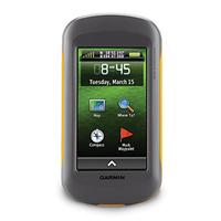
- A 272 by 480 pixel TFT touch panel display, with lots of contrast and a non-glare surface that could probably be easily viewed inside the orbit of Mercury.
- Three gigabytes of internal memory, expandable with SD cards if you turn out to be a map glutton.
- A three-axis compass and a barometric altimeter. Admittedly, there are no summits anywhere near us to make that latter feature of much practical use, but it’s cool just the same.
- Spoken turn-by-turn directions, if you install a road map database. You can even select the voice you’d like it to use. Being able to hear it speak its directions, however, may prove to be an issue, as we’ll get to momentarily.
- Room for up to 4000 waypoints. There are GPS receivers with more capacious waypoint storage, but let’s get real…
The operating system of the Montana 600 is well thought-out and stable. Once you get used to the location of the principle items on its screen, it’s easy to configure and navigate. The placement of its icons can be customized, to locate the items you’re likely to use where you’re likely to use them.
One of the early issues that users of the Montana 600 are likely to encounter is that its printed documentation is diaphanously superficial, and it offers little more than assistance with initially powering up the device. There is a somewhat terse but decidedly more extensive manual for it, but it’s only provided as a PDF file. Unlike technology that ships its detailed documentation on a CD-ROM to save on printing costs, the Montana 600’s PDF manual is stored on the device itself, and users new to this technology will probably have to spend a while tracking it down. I hasten to add that the Montana 600 lacks any way to view PDF documents – you can only read the manual by connecting the GPS to a computer, and browsing it through Windows Explorer.
The Montana’s manual document is actually formatted to present itself as a small booklet. Had it been provided in print, it could have been easily carried with the device. As it is, it’s just unnecessarily awkward to read on screen. Once again, considering what the Montana 600 costs, a real paper manual would have been appropriate.
The more extensive PDF documentation does omit a lot of essential information concerning the initial configuration of the Montana 600 – we ultimately learned the toll-free number for Garmin’s support staff by heart.
The other issue that we encountered early in our exploration of the Montana 600 is that while it includes an internal speaker of sorts, its spoken turn-by-turn driving instructions can’t be heard through it – the internal speaker only generates warning beeps and other digital noises. To have it speak while you’re driving, you’ll need to do one of the following:
- Plug a set of headphones or ear buds into it. I’m of the opinion that people who drive while they’re wearing headphones should be directed off the nearest cliff, for the protection of the rest of us.
- Plug it into the sound system of your vehicle… assuming that your vehicle’s sound system has an auxiliary input jack. This is easily the simplest way to resolve this issue, if you don’t want to listen to your sound system do anything other than provide directions while you drive.
- Place the Montana 600 in an optional dashboard “cradle,” which provides it with power and a speaker. Aside from increasing the price of the system by a further seventy dollars or so and requiring that the beast be plugged into the cigarette lighter of its parent vehicle every time it’s to be used, I’m ill-disposed to dashboard-mounted technology, which is wont to turn into cabin shrapnel in the event of a collision.
- Plug it into a small battery-powered laptop speaker. This is arguably the least nettlesome resolution to the Montana’s lack of voice. In that the device has a USB port, the capability of its speaking through a USB-powered speaker would have been cool… but this doesn’t appear to have been implemented.
In that the principal attraction of the Montana 600 – and the primary justification for its stratospheric price – is that it’s intended to be equally at home on the road and in the wilderness, having it perform as a fully-functional automobile navigation system – complete with self-contained spoken directions – seems like it should have been an essential aspect of its design.
As an aside, once you do allow the Montana 600 to find its voice, be aware that it doesn’t default to navigating for automobiles, and as such, its spoken turn-by-turn instructions won’t work for driving. As it comes out of the box, it wants to navigate “as the crow flies,” that is, in a straight line to wherever you want to go. As it took us several days and a few calls to Garmin’s support line to resolve this, we’d like to point out that you need to select the Automotive profile, and you need to use the Setup → Routing → Activity item to set the Activity for Route Calculation to Automobile Driving before the spoken turn-by-turn directions will be audible.
Every journey with the Montana 600 can be an adventure. Our house is fairly deep into the woods – when we approach it, rather than something like “turn into your driveway after 300 meters,” the Montana says “after 300 meters, prepare to go off road.” No foolin’…
The Drive
The Montana 600 allows for the management of an extensive list of points of interest. The City Navigator North American NT database we installed on it included some eight million place locations, which are searchable through the device. Its on-screen keyboard will allow it to search for pretty much anywhere you’d like to drive to. The scope of its database is just this side of unbelievable – it proved to include entries for all but unheard-of restaurants and the independent garage that services my sports car, as well as every shopping mall, fast food emporium and pay-as-you-go wilderness on the continent. Broad searches can be somewhat time-consuming, but in fairness, far less so than unfolding a paper map.
It also has a substantial number of dedicated searches built into its user interface – it will, for example, provide you with a list of nearby gas stations and grocery stores arranged in order of proximity.
Items found through searches of the Points of Interest database are automatically added to the Montana’s internal Recent Finds list, to make them readily accessible should you want to drive there again in the near future.
You can add your own points of interest to the system from a computer, but this is markedly less elegant than the points of interest management of the Montana 600 itself. You’ll need to download something called POI Loader from Garmin’s web page, a crude Windows application that will read points of interest stored as CSV spreadsheet documents and upload them to the GPS. It’s awkward to use, and for practical purposes, if you aren’t prepared to edit the CSV files it inhales by hand before you fire up POI Loader, it’s just this side of unworkable.
There are several on-line sources of free downloadable points of interest lists stored as CSV files, and you can substantially enhance the Montana 600’s already extensive database of locations this way, should you have a few hours to kill.
The Points of Interest functionality of the Montana 600 does include a few blind spots. It does not, as far as we’ve been able to determine, allow you to create a point of interest for an arbitrary location by simply pointing on its screen to where you’d like to go. We have several friends who live on private roads buried deep in the bush – the Montana 600’s driving database really doesn’t want to go there.
The ancillary features of the Garmin Montana 600 are legion, and I suspect that no two putative users of this device would enjoy the same combination of toys. Among the ones that we’ve found useful are:
- An internal calculator – morphing into a scientific calculator, if you happen to need one.
- A function to calculate the area of an irregular patch of ground. We’ve used it to determine how large our beaver pond is, among other things. Evicting the beavers doesn’t appear to be within its capabilities.
- A photo viewer, so you can store pictures of your family or your favorite cars on your GPS. I have no idea why this seems appealing, but it does.
- It can be a stopwatch and an alarm clock. If you need an alarm clock when you’re out in the wilderness, you’re doing it wrong.
- A punctiliously accurate compass, albeit only after it’s been calibrated.
The Montana 600 also includes extensive support for geocaching… the sport of wandering around in the woods looking for stuff left there by other GPS users, while trying to avoid the places where the bears hang out… and for wirelessly sharing data between GPS devices. I confess that we haven’t gotten involved with either.
The Montana 600 is a very cool GPS, and while it embodies a number of rough edges and issues that could have benefited with one more pass though Garmin’s engineering department, it’s arguably as close as we could get to a receiver that nailed all our criteria. It’s all but indestructible, it has user-replaceable batteries to keep it going pretty much indefinitely, it’s suitable for both the road and the back woods and it will access a rich, detailed map database. Once it has surmounted its varied setup imbroglios and the credit card bill for it has been settled, it would be difficult not to like.
thanks for the map installer tip. I was about to lose it…